ALL THE WAY FROM WICKENDORF TO WICKENDEN
FROM WICKENDORF TO WICKENDEN
CONTENTS
- Pre-history of the Wickendens: 5 hypotheses
- WICKEN - The Wicks or Wicken (in Latin, the Hwicce) were a family group or clan of Angles. Like many other den names, the folk whose name in an "enden" form was attached to this den, were called Wicken, plural of Wick. There is place name evidence for a long history of this name stretching across the continent and southern England. Therefore, it is probably not derived from any local geographical, topographical, sociological or botanical feature, except at its origin deep in the heart of Germany.
- WICKENDORF - The Wicken came out of locations like Wickendorf in central Germany and moved north to Angeln
- MIGRATION - Some of the Wicken moved to the Frankish coast through locations like Wickenberg and were part of the first migration of Germanic tribes from the Continent across the Channel to Britain
- WICKENDEN - The Wickendens descended from some of the Wicken who established a den in the Weald of Kent
- KINGDOM OF HWICCE - Other Wicken also continued to move West and settled the Kingdom of Hwicce in South-Central England
- Evidence, including maps
- Location of the Wicken on the Continent
- Location of the Wicken on the Jutland Peninsula
- Location of the Wicken on Thanet
- Location of the Wicken along the Thames
- Location of the Wickenden in Cowden and the Manor of Lewisham
- Location of Wicken in the Kingdom of Hwicce
- Life and Values of the Wickenden Clan
- Published articles about Wickenden prehistory
THE PRE-HISTORY OF THE WICKENDENS
The basic historical claim made in this section is that the Wickendens were once Wicken, that the Wicken were a large family group or clan affiliated with the Germanic tribe known as Angles and that they settled dens in Kent, including Wickenden, as well as in an area in south-central England known as the Kingdom of Hwicce.. The intention is to provide evidence for this claim by adding information from various sources. Also a trip may be planned to track the possible movement of the clan of Wicken, starting around Vienna, then up to Angeln, down to the coast and across the channel to Thanet, over to the west of Rochester on the south shore of the Thames, and then down one of the droves through the Sutton-at-Hone commons to Cowden in Kent. This conjecture is based upon several hypotheses for which evidence will be provided. Working backward, from the documentation of the earliest Wickendens in Cowden, Kent, England, these hypotheses are as follows:
1. WICKEN- The first hypothesis is that the Wicken who established the Wicken den in the parish of Cowden were part of the clan of Angles known in Latin as Hwicce. There are a variety of Wicken place names similar to Wickenden that mark the location of the Kingdom of Hwicce and earlier locations in Germany and Austria. These names include Wickendorf, Wickenburg, Wychdene, and Wichenford. (See the pages on The History of Wickenden, Wickendens of Cowden, and the Kingdom of Hwicce for more information on this topic.)
2. WICKENDORF AND WICKENBURG - The second hypothesis is that the Hwicce were part of the tribe of Angles whose origin was somewhere in the heart of Germany and that they moved with that tribe to the coast of the North Sea. There are various historical locations on the map of Austria, Bavaria, Germany and Poland named "Wickendorf" and "Wickenburg." There are also a number of historical figures from Germany and Austria whose name is von Wickenburg, and, in addition, Henry Wickenburg, who located a (gold?) mine and founded a nearby town in Arizona by that name, was know to have emigrated from Austria in the mid 19th century and had worked in a family (coal?) mine near Essen, Germany.
3. MIGRATION - The fourth hypothesis is that the Wicken were living close to the Jutes near the coast of the North Sea, and therefore migrated to a location in Britain to the north and west of the Jutes and that they were part of the earliest reported migration of Anglo-Saxons to serve as mercenaries for the British and therefore were granted land on the island of Thanet and later, perhaps after the British retreated to London, moved from there to settle along the shore of the Thames, apart from both the Saxons to the South and East and the Mercian and Angles to the North. There are Wicken-related names in Thanet and along the Thames, suggesting that some Wicks may have migrated south into Kent along a drove from that general area. Since there are Wicken-related place names both on the continent and in England, and since the Kingdom of Hwicce (and later the Earldom of Hwicce) was a separate territory from those named after the Angles, it is likely that the Wicken were a substantial clan or even a small, separate tribe, recognizing that the Germanic tribes often intermingled and intermarried.
4. WICKENDEN - The fourth hypothesis is that the Wickendens descended from the Wicken who established and took their name from a den in the parish of Cowden, In this document, the Wicken who became Wickendens will be identified as Wicken as will the clan of which they may have been a part. However, with respect to the Kingdom and Earldom, they will be identified by their Latin name of Hwicce. (See the articles on The Wickendens of Cowden and Pathways to Cowden for more information on this topic.)
5. KINGDOM OF HWICCE - The fifth hypothesis is that while the Wicken (who became Wickendens) were part of the earliest reported migrations of Angles and Saxons to serve as mercenaries and settle in Kent, other Wicken may have migrated further and/or settled later, continued resisting the British, perhaps even participated in the battles against the leader know in legend as King Arthur, and that eventually these Hwicce settled further along the Thames and to the West, establishing in the Midlands what was know as the Kingdom of Hwicce. The historical record for the Kingdom of Hwicce is well established. The shortest route to the territory thought to have been the site of the Kingdom of Hwicce is along the Thames and then west, although other possible routes include travel from the north through East Anglia and then along the Icknield Way or from the south starting at the Isle of Wight and proceeding northward to Bath and beyond. (See the article on The Kingdom of Hwicce for more information on this topic.)
SOME DETAILED EVIDENCE INCLUDING MAPS
Location of the Wicken on the Continent - The Wicken are evidenced on the Continent by names such as Wickendorf and Wickenburg. There are nearly a dozen von Wickenburgs mentioned in German history databases, and Henry Wickenburg came to Arizona from an area near Essen, Germany, where his family worked a coal mine.
Wickendorf is reported in the German Wikipedia to be the name of the following five locations, where the larger city or town within which Wickendorf was a village or distrrict is given parenthetically:
- Wickendorf (Witków), village in the Gmina Jaworzyna Śląska in the powiat Świdnicki in the Lower Silesian Voivodeship in south-western Poland
- Wickendorf (Wolfern) , place near Wolfern , Steyr-Land, upper Austria
- Wickendorf (Teuschnitz) , district of the city Teuschnitz in the district of Kronach in Bavaria (southern Germany)
- Wickendorf (Probstzella) , hamlet of the municipality Probstzella in the district of Saalfeld-Rudolstadt in Thuringia, central Germany
- Wickendorf (Schwerin) , part of the city of Schwerin in Mecklenburg-Vorpommern, northern Germany
 Places named Wickendorf in (1) Witkow, Poland, (2) Wolfern, Austria, (3) Teuschnitz, Bavaria, (4) Probstzella, central Germany, and in (4) Schwerin, northern Germany.
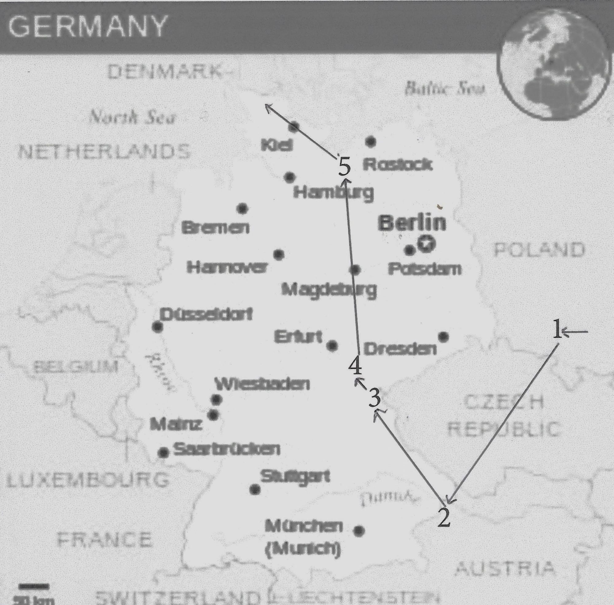
It may have been that the Hwicce began to identify as a separate clan when they were located in Poland or somewhere near Wolfern in Austria. Under pressure from tribes invading from the east, they may have moved slowly to the north, and from there to the North Sea Coast. The locations of the Wickendorfs have been numbered to indicate this possible sequence over time.
1. Witków (Wickendorf ) is a village in the Gmina Jaworzyna Śląska (German royal tent ) in the powiat Świdnicki in the Lower Silesian Voivodeship in Poland. Wickendorf was founded in the course of the Eastern colonization of German settlers. In 1392 the place appears in a document as Wittchindorff . In 1497 the Schweidnitzer patrician Georg Ungerothen was lord of Wickendorf. With the takeover in 1945 by Soviet troops and Polish administration, Wickendorf was renamed in Witków
2. Wolfern - Wickendorf is a place near Wolfern, a market town with 3,163 inhabitants (as of 1 January 2019) in Upper Austria in the district of Steyr-Land in Traunviertel . The competent judicial district is Steyr . The colonization of this area goes back far into the dark past, as finds of hole stone axes and flat axes from the Stone Age report. But in 777 we find the first documentary mention of this area in connection with the Bavarian Duke Tassilo III. The Kremsmünster Abbey, founded by the Duke, donated the forest between Dietach and Sierning. In 871 Emperor Charlemagne confirmed this donation. In this time also the name Wolfern originated from the Slavic word "woularin". From this word the meaning "forest between Dietach and Sierning" can be derived. The name Wolfern first appeared in 1111.
3. Teuschnitz - Wickendorf is a rural village, which lies in the valley Frankenwald. Through the town flows the Teuschnitz, a river which flows at Wilhelmsthal - Gifting in the Kremnitz . A municipal connecting road connects the village with Teuschnitz and with state road 2198 . The county town of Kronach is located south about 20 kilometers away. The first appointment of the village was on July 18, 1361. [2] Wickendorf belonged to the Bishopric of Bamberg . By the Reichsdeputationshauptschluss the village went in 1803 together with the remaining areas of the Bishopric Bamberg in the possession of the Electorate of Bavaria . In 1862, the rural community Wickendorf was incorporated into the newly created Bavarian district office Teuschnitz . It consisted of two villages, the village Wickendorf and the three kilometers away Einöde Rauschenberg, and it belonged to the district court Ludwigsstadt . In 1871 the village had 358 inhabitants, and 57 residential buildings. As part of the territorial reform in Bavaria , the municipality Wickendorf was incorporated on January 1, 1978 to Teuschnitz. [10]
4. Probstzella - Wickendorf is located east of the road from Großgeschwenda to Lichtentanne in the source trough of Schaf Bach river flowing to the Sormitz in 570 meters above sea level. The corridor of the hamlet is 225.06 hectares. ... On March 19, 1454 the hamlet was first mentioned in a document. In 1417 there were several farms in the hamlet, then a farm was created from the farmsteads , which was again divided in 1780. There was then a sheep farm with about 700 sheep. There were four houses and 26 inhabitants. The place was [known] as Roda until 1918 in the People's area of the supremacy of the Principality of Schwarzburg-Rudolstadt . ... On April 6, 1994, the community Roda, which belonged to Wickendorf, [was] incorporated into Probstzella.
5. Schwerin - Wickendorf is part of the city of Schwerin, which is the capital of Mecklenburg-Vorpommern . With almost 96,000 inhabitants, the district- center city is the smallest of all state capitals in Germany, but at the same time, after Rostock , the second largest city and one of the four major centers of their state. ... Schwerin was first mentioned in 1018 as Wendenburg and received city rights in 1164, granted by Henry the Lion . This makes it the oldest city in Mecklenburg-Vorpommern today. The Germanic Wikipedia also mentions a canal called the Wickendorf Canal in Germany.
It is difficult to know when the Wicken may have settled at these locations, but the general movement of the Germanic tribes, under pressure from the Huns and seeking arable land outside that defended by the Romans was from East to West and then from South to North. It is possible that the Wicken spent enough time in each of these locations for their name to be associated with the settlements. As the Germanic tribes were pushed to the west and then north by the Huns, the Wicken may have moved from a location in Upper Austria or Poland, northward through Bavaria and Germany into Northern Germany, close to Slesvig. The Angles apparently settled for a while in an area north-east of Slesvig now called Angeln, a German province in the southern part of the Jutland peninsula.
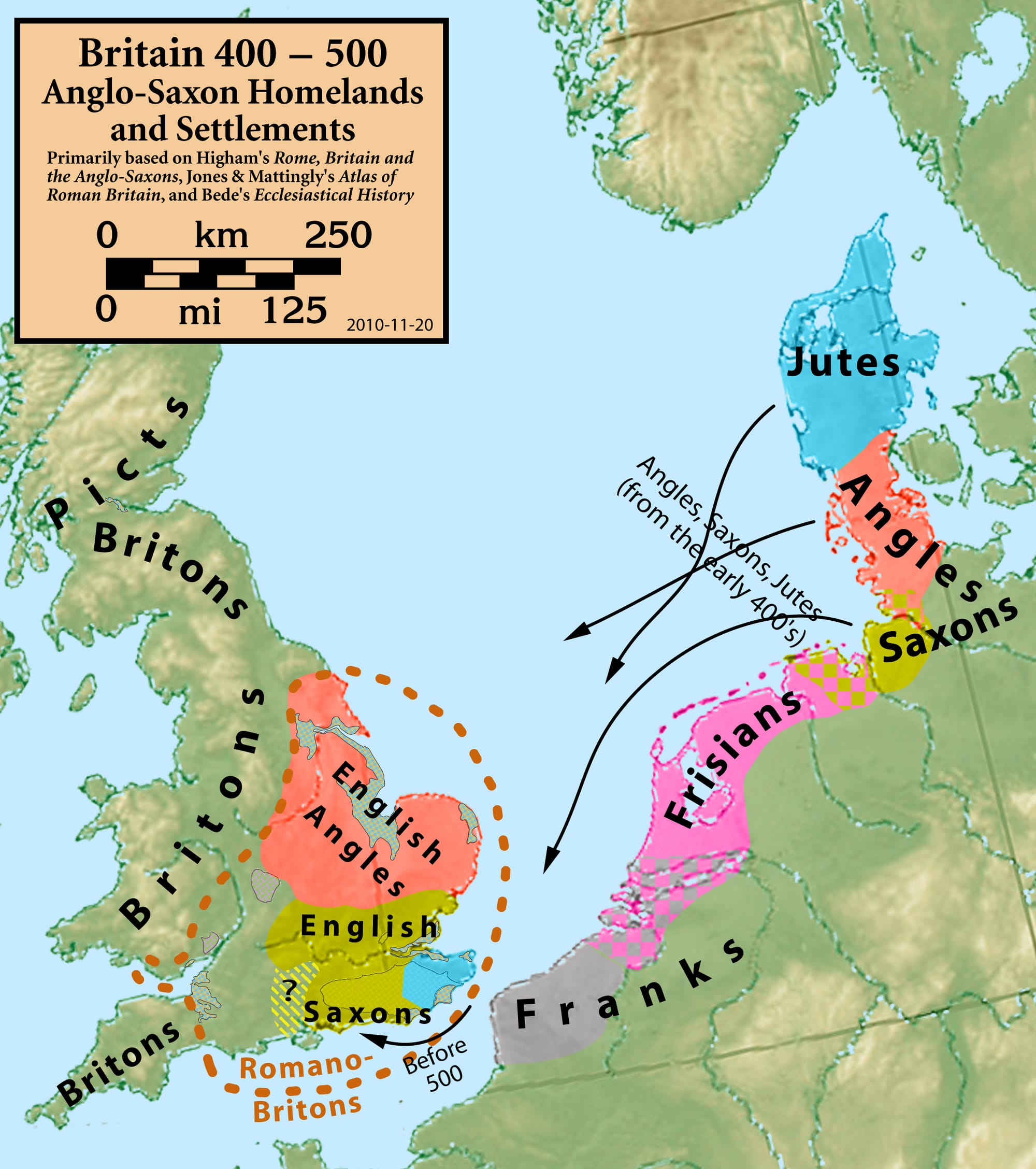
Location of the Hwicce on the North Sea Coast - The map to the right shows where the Angles were located prior to their migration to Britain.  According to Hunter (p. 9), "the evidence of Widwid [ an Old English Poem] combined with that of Tacitus, Bede and Alfred, justifies the belief that the English lived in the southern part of the Jutland peninsula before they migrated to Britain." The Saxons were thought to be situated south of the river Elder, while the Jutes may have been located north of the Angles or may have moved further south to the Frankish Rhineland. While other Angles settled what came to be identified as several kingdoms including Middle Anglia and East Anglia (which is divided into Norfolk - the North Folk - and Suffolk - the South Folk - down to the north shore of the Thames), the Wicken settled along the south shore of the Thames and on to the southern midlands West of London.
While the general location of the Germanic tribes on the map are not incorrect, the arrows on this map are somewhat misleading because, as Fisher (p. 24-26) points out, "all the tribes of north-west Germany were continuously on the move; such movements probably contributed to the diminution of racial distinctions among them." In a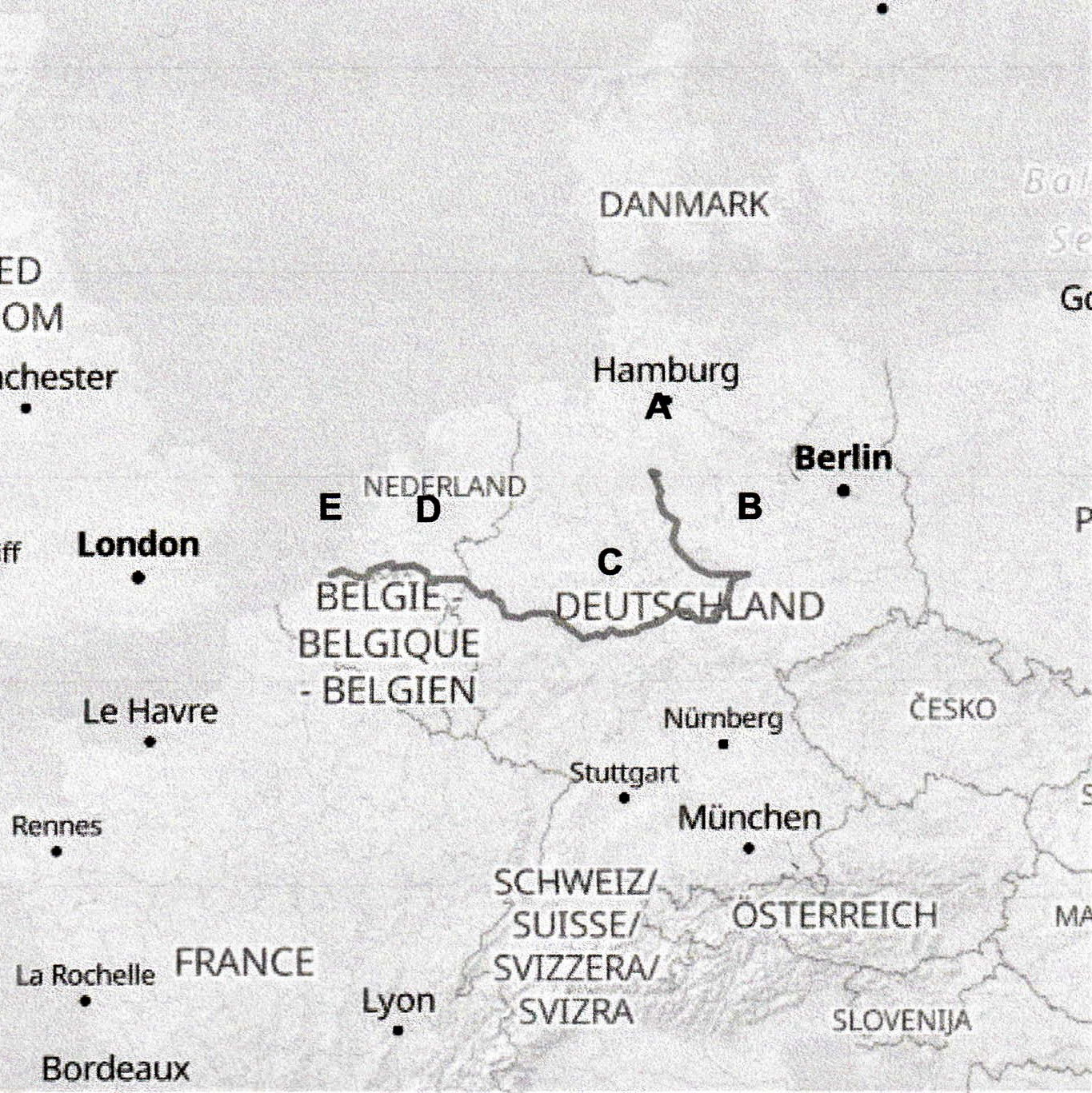 Places named Wieckenberg (A), Wicken-Berg, Seegebiet Mansfelder Land (B), Wickenberg, Amoneburg (C), Wickenburg, Eindhoven (D), and Wickenburg, Vissingen (E). ddition, sailing in small, open boats, few of the tribal groups ventured out and across the North Sea, though some probably worked their way down the Elbe or other rivers and then south along the Frisian coast to the territory of the Franks before crossing the Channel, which at that point is approximately 20 miles wide.
Apparently the Germanic tribes began to seek better land for raising pigs, sheep, cattle and crops than what they found on the Jutland Peninsula. There may also have been a significant drought in the region at this time (add reference here). Place name evidence related to Wickenburg and Wickenberg suggests, as shown on the map to the right, that most of the Hwicce, may have traveled south by an inland route, skirting around territory settled by other tribes and then turned west to the coast in the south of what is now the Netherlands. From there they may have responded to calls from the British or the first Saxons and Angles to join them in what would soon be known as Angle land.
Roman Rule of Britain ended in 410 CE. After decades in which the Romans and then the British fought to defend Britain from attacks by the Celts (Pics and Scots) from the north as well as the Germanic tribes (generally referred to as Saxons) from the Continent across the Channel to the "Saxon Shore" in the east, the British requested assistance from the Roman Emperor Honorius, who wrote that the local civitates defend themselves as best they could.
Anglo-Saxon Clans - The earliest recorded migration of Anglo-Saxons to Britain was in response to an invitation, issued by Vortigern around 450 CE for them to serve as mercenaries to help the British defend against the Pics and Scots. After such service they fought to stay and were granted land at the southeastern most end of the Thames, specifically, the island of Thanet. Therefore, it is possible that the Wicken who settled further to the west along that same shore and later established the Wicken Den were part of, or subsequently emigrated to join, the initial force of Anglian mercenaries. Since the Wicken who moved further on to the west of London were not only separate from the other Angles but also were populous and widespread enough for their domain to be considered a sub-Kingdom, it is likely that the clan of Wicken was one of the largest clans within the Angle tribe. Of course many of these and other Angle clans may also have moved into the other areas in England associated with the Angles - East Anglia (Norfolk and Suffolk), Middle Anglia, and Mercia, not to mention those primarily associated with the Jutes and Saxons. Place name evidence suggests that the Wicken were not the only Germanic tribal clan to cross the Channel and move into Kent. The attached table lists the names of 15 family groups in addition to "Wicken" who appear to have moved from the Continent and into Kent: Possible Clan Names.docx.
Location of the Wicken on Thanet - Homer Wickenden indicates in his chapter on the history of Wickenden that the family had once owned the island of Thanet, and he says that Alfred checked this out and found it to be true. If the Wicks were part of the Hwicce and if the Hwicce were among the first Angles and Saxons to migrate to serve as mercenaries for the British, this is supported by historical documents. According the Wikipedia, "Vortigern, King of the Britons, was under attack from other tribes and called for assistance. Among them were the Jutes, Hengist and Horsa; he is said to have rewarded them with the Isle of Thanet in return for their services. As the following extract from the Historia Brittonum (first written sometime shortly after 833) testifies:
Then came three keels, driven into exile from Germany. In them were the brothers Horsa and Hengest ... Vortigern welcomed them, and handed over to them the island that in their language is called Thanet, in British Ruoihm.[8]
Ewing (p. 17) notes that "It was not till the Jutish occupation after the departure of the Romans in 411, A.D., that the country was over-run by Angles, Jutes and Saxons, who, led by hengist and Horsa, invaded Kent from overseas, landing at Ebbsfleet in Thanet in 499 A.D., and after two centuries of war, occupied Angerida, and "slew all that were herein, nor was there afterwards one Briton left," at any rate in Kent, according to Canon Horsley (Place-names of Kent).
Place-Names Cluster- There is a geographical cluster of names just East of Canterbury, at the edge of the Wantsum channel and Stour river that separated the Island of Thanet from the mainland. Each of these suggests a possible connection to the Wicken, and the clustering in this location, especially in the absence of documented alternatives, provides strong evidence that the Wicken settled in this region after crossing from the Continent. These places are Wickhambreux, Ickham, and Wingham. Wickhambreux is less than half a mile, down Wickham Road and Wingham lane, from Ickham. Ickham, in turn, is less than two miles, further down Wingham lane and across Wingham River from Wingham. These are all ancient names, but while explanations differ, their exact origin is not certain. All the suffixes include "ham," which serves to identify the locations as villages or hamlets. Interestingly, although, each of the Prefixes could be a varient spelling of Wick . Further research should be conducted to see if this is a possibility, in which case the clustering of these names might be evidence that the Wicken settled in this area shortly after crossing the channel. Alternatively, although the explanations suggested for these names are very weak, the clustering might just be a coincidence and the names not related to the Wicken.
Wickhambreux - In the Domesday Book the village is referred to as Wicheham. The derivation appears to be Anglo Saxon and is formed from Wich (Wich town), meaning coastal trading settlement and Ham, meaning homestead or settlement.[4] Although this is surprising today, in Roman Britain and Anglo-Saxon England the village was near the mouth of the Little Stour or Lesser Stour, where it entered the Wantsum Channel. (Wikipedia) This was the channel separating the island of Thanet from the mainland. The suffix "breux" was added later, referring to the de Breuhouse manor.
Ickham - Ickham, a village and a parish in Kent. The village stands on the Little Stour river, 4½ E of Canterbury, and was anciently called Yecham (Wikipedia). Ickham may designate the farm of a person named Ica .
Wingham - As an example, he village called Wingham is located just west of Thanet. According to Wikipedia: "Wingham /ˈwɪŋəm/ is a village and civil parish in the Dover District of Kent, England. It is on the ancient coastal road, now the A257, from Richborough to London, close to Canterbury. ... It has existed since the Stone Age, but only became established as a village in the Roman era. In the Domesday book, the Anglo-Saxon manor was in the possession of the Archbishop of Canterbury.[2] Wingham was the administrative centre of the hundred of Wingham,[3] which included Fleet. " (Wikipedia)
Wychdene - Most of the folk who led their pigs and cows down the droves to establish dens within the oak forests of the Weald in Kent started their journey somewhere along the south shore of the Thames. There are several extant places with den names in this area, including Hersden, Chillienden, Hoaden and Showden. There is also evidence of provided by place names that may have derived from the Wicken. As an example, there is an institution located in or near what had originally been the island of Thanet know as the "Wychdene Care Home." We have inquired about the origin of this place-name, since it may indicate that some Wicken were located in this part of Thanet, perhaps in a den established shortly after the time of Horsa and Hengest. Results will be posted in this space.
Location of the Wicken along the Thames
Ackroyd states that according to the Kentish chronicles the British allies of Vortigern become alarmed at the cost of the Anglo-Saxon presence, and they declared 'we cannot feed and clothe you, because your numbers have grown. Leave us. We no longer need your assistance.' Ackroyd (p. 46-47) notes that "the reaction of the mercenaries was immediate and strong. Their insurgency began in East Anglia and then spread down to the Thames Valley. They took over many of the towns and countryside areas in which they had been stationed. ... They had seen at first hand the prosperity of the land and had acquired a taste for it. Thanet itself, as a granary, was a golden prize. The Saxon federates then sent out a call to their compatriots. Come and settle here. Together we can master the natives."
Wickford and the river Wick- Other evidence is provided by a town called Wickford on the north shore of the Thames, just west of the river Medway. There are two rivers whose fords may have given rise to the place name. According to Wikipedia: "For the most part, Wickford is flat and 10 metres (33 ft) above sea level. The highest point, on the outskirts of the town, is 74 metres (243 ft) above sea level. The River Crouch flows through the town, from the west to the east. The River Wick flows into the River Crouch from the south. The name of that river gives another indication that a group of Hwicce may have settled in the area, which was already inhabited and developed when they arrived, with easy access from the Thames.
According to Wikipedia: "Wickford has a history going back over two thousand years. There is evidence that the area itself was inhabited in prehistoric times probably by a tribe of Britons called Trinovantes. There was a Roman military marching camp on the Beauchamps Farm site, which was succeeded by a Roman villa. This is now the site of Beauchamps High School. This area on higher ground was the historic core of Wickford, the site of the manor house and the parish church of St Catherine's. Over time the commercial centre of Wickford has migrated westwards, towards the modern High Street on the other side of the River Crouch.[2]
The place-name Wickford is first attested in a Saxon charter of 995, where it appears as Wicford. It appears in the Domesday Book of 1086 as Wincfort. The name means 'ford by a wych elm or ford by a dairy-farm'.[3] Raymond, whose book is cited by Wikipedia, notes other spellings including Wygford and Wyckford.
Before the 20th century Wickford was an agricultural village. At the time of the Domesday Survey, six land-holders were recorded. Historically there have been only two considerable estates in Wickford, the manor of Wickford Hall and the manor of Stilemans. Robert Wikeford or de Wickford (1330–90), Archbishop of Dublin, was born in Wickford, and his family are thought to have been Lords of the Manor of Wickford Hall.[4]" It should be noted that while Wickford is similar to other Wicken names, it does not include the plural form "Wicken" and may have arisen instead from a reference to the Wick Elm tree, or from the Latin word for village "vick", or to indicate a Viking settlement from the time when they invaded the northern and eastern shores of England, and gave rise to names such as Wickham. It is also located in Surrey on the north shore of the Thames estuary. Nevertheless, if people located near and using a river ford were more relevant than a common type of tree growing nearby in a generally forested land, it may provide evidence that at one time, prior to Viking raids, the Wicken traveled up the Thames river and settled on either side, to the east of London, prior to moving down through Kent to form dens in the forest known as the Weald.
West Wickham and Wickes - 20 miles north of Cowden, on the road from Lewes to London, through Edenbridge, lies West Wickham, whose name is a possible indication of Wicken settlement. Down the road about a mile toward Croyden (now A232) is situated another indication, a building materials supply store established by the Wickes family. To the east side of the road are some remains of the large Sutton-at-hone commons, now labeled Bromley Common and Hayes Common. According to Wikipedia, UK, the history of West Wickham predates the Norman conquest of England in 1066.[1] West Wickham is mentioned in the Domesday book [1086] with the following entry: "In lordship 2 ploughs. 24 villagers have 4 ploughs. 13 salves; a church; a mill at 20d.; a wood at 10 pigs. Value before 1066 8; later 6: now 13. Godric son of Karl held it from King Edward".[1]
Movement of the Wicken through Kent to the Weald
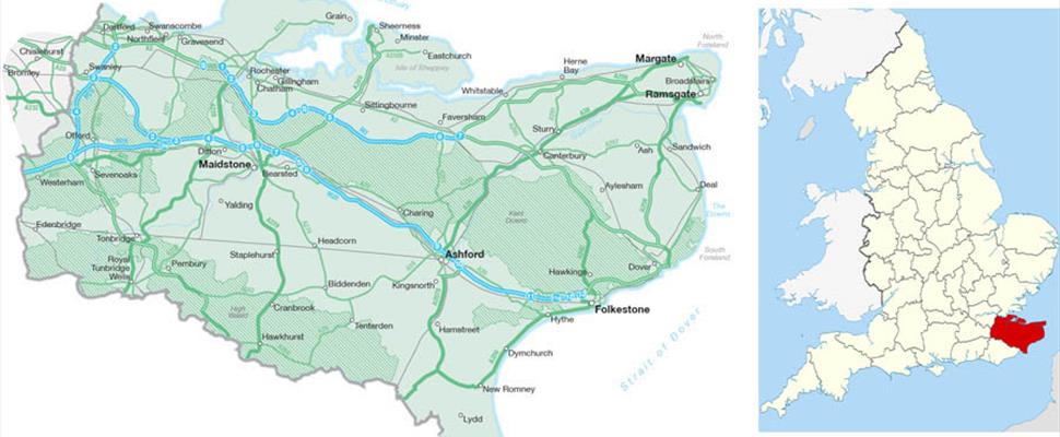
The Weald - As Witney states, "The Weald of Kent forms only a part of the great Forest of Andredsweald which once filled the whole central basin of South-east England; a vast expanse of oak wood, enclosed north, west and south by chalk hills and in the east opening on marsh and the sea" (p. 1). "The Weald ... is an area about thirty-five miles in width from west to east and with a depth varying from about ten miles in the west [where Cowden is located] to twenty in the east. It is divided laterally into two belts of land of equal depth, the Vale of Kent at the foot of the Chart Hills and the High Weald along the Sussex border" (p. 10).
Dens and Den Names - Dens were a common feature of the Weald. While much of the land in Kent was designated as commons, there were certain pastures in them called "dens" to indicate that they were "swine pastures bearing acorns in the Weald." The practice or right of feeding swine on acorns and other "mast" (acorns, nuts, fruit, and berries) from the forest was known as "pannage." As Witney notes, these early dens were created "through regular and undisputed occupation by the free ceorls who made use of the commons, in which they were mere lodgements."
Since the woods and pastures of a tenement lay often a considerable distance from the farmstead, it necessitated a great annual transmigration of stock to their fattening grounds, whether sheep to the marsh or swine to the forest; and although the Wealden pannage season fell at a relatively dead time of the farming year,...the pannage season lasted for some seven weeks, during all of which the herdsmen were compelled to live exiled from their homes in a distant, damp and inhospitable forest" (p. 58). "Not only did the pannage season last for seven weeks, but those were among the wettest of the year, when the sun was losing its power, the leaves were falling, and the clay droves coming more and more to be turned into morass. It is not to be supposed that the herdsmen spent the season wandering at large in he forest; they must have built for themselves rough shelters of boughs as protection from the wind and rain, with pens nearby for their swine.... As time went on, there would be a tendency for drovers from the same upland holdings to return to the same places year after year, and by this constant occupation to establish some sort of squatter's rights to them" (p. 73).
As it was being settled by the Anglo-Saxon and Jutes, "the Weald was left in its original forest state to serve as a vast commons where herds of swine could be fattened on acorns and beech mast; the earliest place-names being those of the swine pasture or 'den-baera' [emphasis added]. Some hundreds of these have survived; they account for the great majority of the names of villages, hamlets and farms and can also be picked up in those of many woods and fields. They do not start to appear in writing until the early eighth century and many of them first appear in medieval documents, but their origin is certainly deeper. Often the names contain those of Jutish kin, and the dens themselves were grouped in a consistent pattern...which seems to have been established very early in the history of the Kentish kingdom. Relating as they do to the primary and prolonged use of the forest, these den names provide the best picture we can get of its features when the Jutes first knew it, and as it must have remained very nearly until the Norman Conquest" (p. 13).
Wickenden - According to the Historical Research Center (1995), "the English name Wickenden is of locative origin deriving from the place where the initial bearer once lived or held land, thus affording him a suitable means of identify in his local community. In this instance, the name appears to derive from a lost place in Cowden, Kent, probably derived from the Old English terms 'wic and dene,' denoting 'a dairy farm in the valley.' now represented by Polefields, first recorded in a charter of 1044 as Wingindene and in one of 1081 as Wigendene. In 1327 it is mentioned in a case tried at Westminster as Wyggenden. It is last mentioned as Wykenden in a list of church marks of 1542 but that of 1663 as Polefields, long occupied by the Wickenden family." By 1461, Thomas Wyckenden was living in Clendene and the original homestead of Wikenden was leased out to Richard Saxpayse, who was the tenant.
There are other Wicken-related names in the area which give weight to the hypothesis that groups of Wicken moved into and settled in the area and that some gave their name to the den:
Wickens and Wichenden - There is an historic homestead still extant in Cowden called Wickens. It is an open question as to whether the Wicken established the Wicken's Farm first and then moved over to establish the Den (which is what Guy Ewing speculates, p. 27), or visa versa, or whether they were established at the same time. This author believes that the Den may have been established earlier, since it is located just off the Roman lane down which the first Wickens may have traveled, whereas the Farm is located across the village. In either case, they both provide evidence of the presence of Wicken in the area.
In addition another possible Wicken-inspired name is "Wichenden (1202) from Frittenden parish, which Witney (p. 214) indicates is now spelled Whitsunden, an example of "the frequent conversion of the vocable 'tch' or 'ch' - usually rendered by 'c' or 'cc' in pre-Conquest documents - into 'ts' or 'ss' because of the inability of the Norman-French to pronounce the sound" (p. 214). According to the entry in Wikipedia, "Roman remains have been found near an old Jutish track which ran through the area, along which pigs were driven into the forest of Andreadsweald. The village itself is named in a charter of 804, and the Anglo Saxon Chronicle of 839 relates that King Ethelwulf of Wessex gave the village land to St. Augustine in Canterbury."
There are other spellings of the original name found in historical documents concerning Cowden. According to Ewing (p. 213), a contract for founding Bell No. 5 in the tower of Cowden Church with 12 pounds was witnessed by John Wickinge and Nich. Wicking, among others.
Winchenden - There is also the land described as Winchenden in the gloss of the fourteenth century Kentish Book of Aid for the Knighting of the Black Prince. Witney notes that this area is marked under that name in Hasted's map of the hundred, just to the east of where Tonbridge railway station is now; and appears there on the Tonbridge tithe map as Wissenden. These are all quite close to Cowden: Wickens is less than one mile to the East of Claydene, Frittenden parish is less than 30 miles to the East, while Tonbridge is 20 miles from Frittenden and about 25 miles from Cowden. These are all Wealden dens, formed, most likely, by family members of the Wicken clan as they moved their animals down the droves from older settlements in the north, closer to the southern foreshore of the Thames.
The Weald - In a masterful study of the part of Kent occupied by the thick ancient forest called the Weald, K. P. Witney notes that despite Bede's description that Kent was settled by the Jutes, "not all of Kent was in origin Jutish. Early pagan cemeteries show that Darent and Cray [river] valleys were first settled by a purely Saxon people, penetrating south from the Thames foreshore"( p. 4). The author also repeats the suggestion by Hodgkin and others that Kent was first settled by "a gathering of federates and adventurers assembled by Hengist from the whole sea-board of north-western Europe" (p. 3).
Prehistoric Tracks, Iron Ways, Roman Roads and Lanes - The author notes that these early settlers followed the roads constructed by the Romans before them as they moved into the island. Most of these roads led from the iron fields in the Weald to the 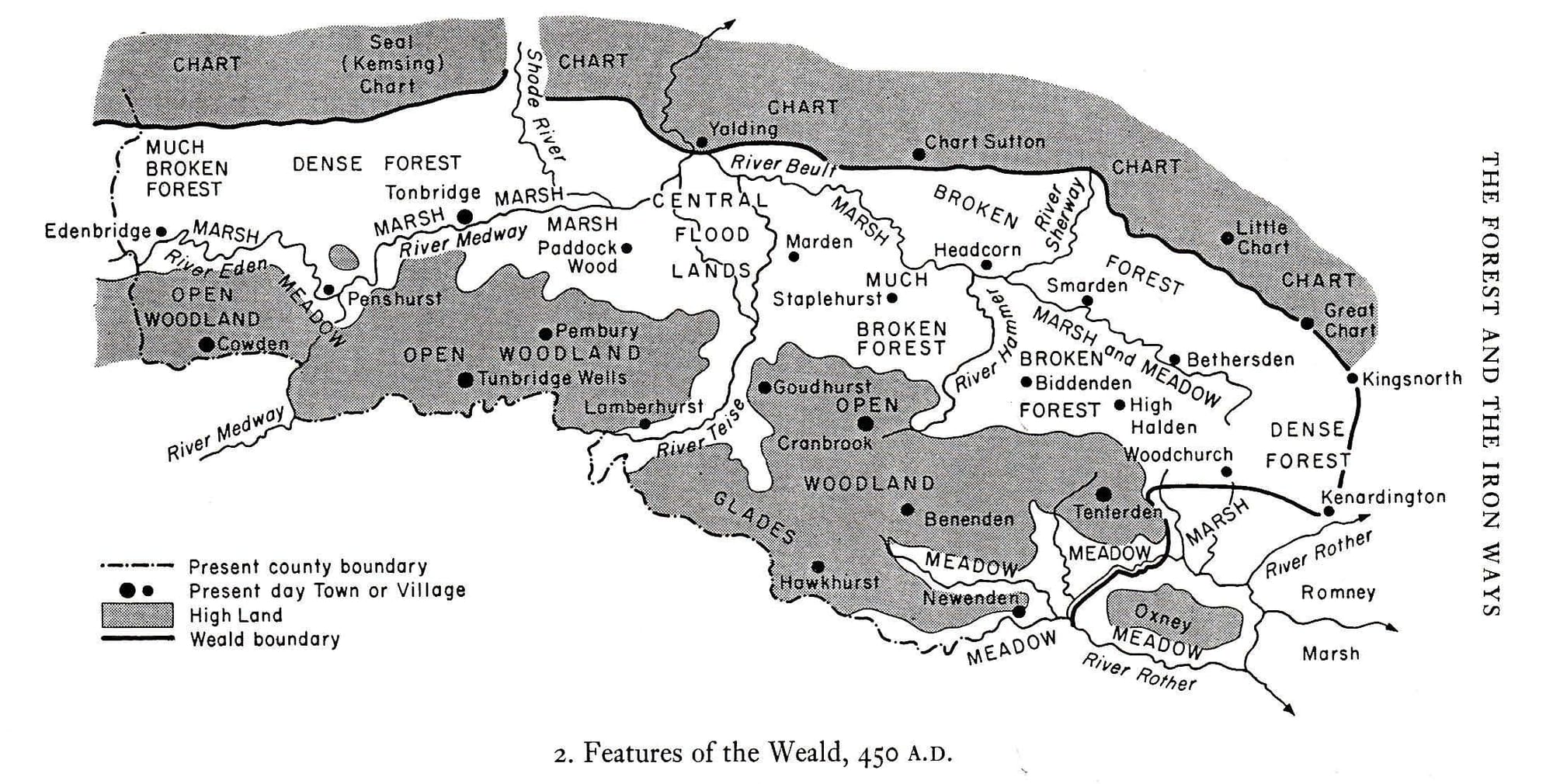 populated areas of northern Kent. "The coming of the iron age led to a more permanent occupation of parts of the High Weald where the iron lodes were to be found close to the surface of the ground and could be smelted with charcoal from local timber. Although most of this prehistoric iron field was in Sussex, it extended into the south-western corner of the Kentish Weald, ... This iron field was developed by the Romans, who built roads to serve it besides maintaining and improving a number of earlier, prehistoric tracks" (p. 17). The Jutes themselves appear to have made no use of the iron field, which was abandoned during the fifth century. The methods used during the Romano-British phase of the Iron Age were simple. "The iron was extracted from shallow pits, which were quickly exhausted and the sites changed; the ore was smelted by a primitive 'bloomery' method, akin in many ways to charcoal burning; and it was then beaten out manually to remove the impurities" (p. 18).The Sussex iron field extended into Kent, and it was through the Kentish Weald that much of the iron was carried out of the forest" (p. 21). For example, "in the west, the road from Lewes to London entered Kent near Cowden and continued through Edenbridge to Westerham and beyond" (p. 21). There is evidence still of this road on the same side of Cowden as Wickenden. Another Roman road called "Spode Road" or now "Spode Lane" as it passes through Cowden, leads right by several of the historic homesteads associated with Wickendens (Polefields, Claydene, Ludwells and Beechenwood) and, as is explained in the page on the "Wickendens of Cowden," passes so close to the location thought to be the site of Wickenden itself that it actually has to bend around the property. Ewing writes that "So far as we know the original roads in Cowden were, first of all Spode Lane, mentioned in the Court Rolls of Cowden Leighton in 1557 [as Spodelane]. ... Though we have, in certain Wills, references of an earlier date than this to other sections of highways within the Parish bounds, it seems probable that Spode Lane was in existence from the earliest of times, and that it was the main artery through the Parish, in continuation of the forest road through Sussex from the sea, which, passing over Holtye at Old Marks, joined the Kent road at Kitford" (p. 226). Spode Lane connected at Dencross with an important road that crossed the Eden river (once called the Medway) at Edenbridge (p. 229).
Roman Camps and Fields - According to Witney, these Roman roads were superimposed upon the earlier system of communications which had served the iron industry in prehistoric times. The early Anglo-Saxons, in turn, used these roads as droves for moving their animals to pastures in the forest. Also as they moved inland down the droves, the Anglo-Saxon settlers gave names to places that often follow a consistent pattern indicating the location of the prehistoric tracks. The Romans had carved out many fields and established camps in connection with the movement and smelting of iron ore in the iron bearing area of the High Weald. Ewing notes that "just outside the Parish, at Dryhill in Lingfield, is a British oppidum or camp, probably the earliest evidence of human occupation" (p. 17). "Polefields," adjacent to the site of Wickenden, associated with and probably constructed by the family, is one of the eighteen place-names in the Weald referring to a field and may have been the location of a pre-historic camp utilized by the iron trade. Ewing notes that "Wyggenden, though the name disappeared as a place-name after 1542, can be identified with Polefields, long occupied by the Wickenden family. There were two tenements in the Parish caled Pollfields, Polefields or Powlfields [indicative of the numerous pools of water in the fields], and it seems probable that Polefields Park was one, lying to the West of Spood Lane, while the other was the land on the East side of the Lane, now part of Claydene." The evidence is fairly clear because we have, among the parish documents, two lists of Church Marks, dated 1542 and 1662, respectively, in which the properties charged with the upkeep of the Church fence are set out in detail, the name of the property called Polefields in the list of 1663 being given as Wykenden in the earlier one. Polefields Park was undoubtedly a tenement of Leighton Manor, which lay to the West of Spood Lane, it seems probable, therefore, that Wickenden lay to the East where the Manor of Lewisham lies.
The Commons, the Lathes and the Droves - Following the Romans, who had build roads that followed and supplemented the ancient iron tracks, the Anglo-Saxon and Jutish settlers and herdsmen developed a system of nine commons aligned with the ancient ways, on which they grazed their animals. In each of the commons they developed a group of droves which followed the Roman roads. These droves served as paths for herding their animals. "The commons, therefore, were corridors of advance into the Weald along which the droves were carried from the borders of the forest into its deepest recesses" (p. 49). "The areas to which commons were attached through the earliest of the Kentish charters were provinces of the Jutish kingdom, known as lathes. Each of the lathes centered upon a royal vill or township, from which it took its name" (p. 31).
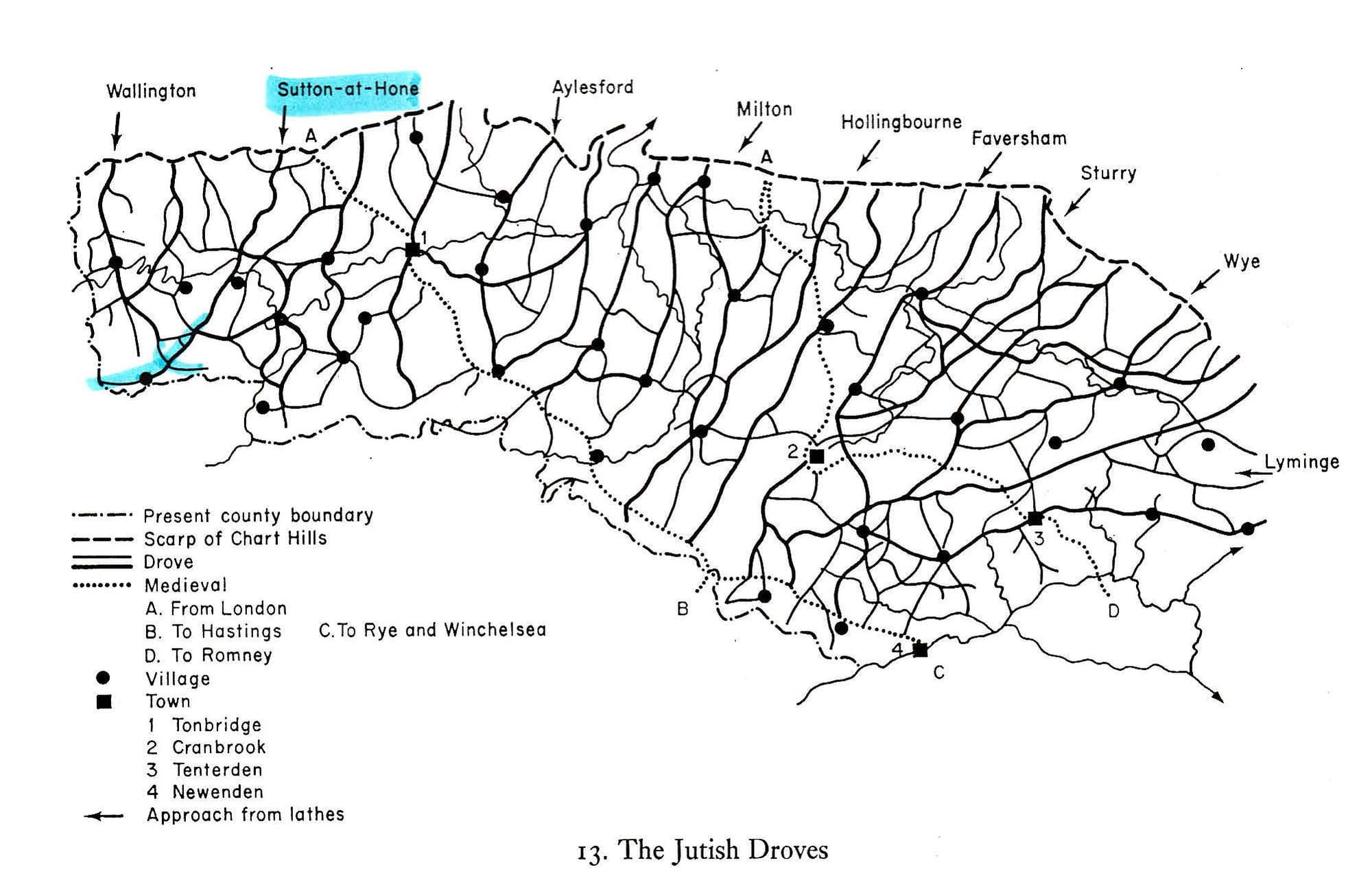
Witney notes that the principle droves were crowded during seven weeks of the autumn with herds of swine from tenements in every part of north Kent, so the droves might provide an indication of the area from which the herdsmen were coming. Since it is apparent from the map of the Jutish Droves that two of these droves, one from the commons of Wallington to the far west of the Weald and the other from the commons of Sutton-at-Hone, just to the east of Wallington cross each other just north of Cowden, it is not immediately clear from which northern location or locations the Wicken may have traveled to the den which they established. This fact is underscored by the name "Dencross" (or the Cross) given to the point at which the two droves intersect. Witney notes in the two cases where the droves cross, that "at each disputed point it was the herdsmen from lathes [the legal territories that emerged from the commons] bordering the Weald ... who gained right of way, presumably because they were first in possession, and those from the northern lathes ... who were checked, because they made less use of the forest" (p. 52). The Wallington and the Sutton-at-Hone commons were roughly equidistant from the Weald, but since the Wallington commons appears to be cut off by Sutton-at-Hone commons, which runs diagonally from northeast to southwest , it is likely therefore that the closest Wicken homestead in Kent (after any others in Thanet and along the south shore of the Thames), was located in the vicinity of the Sutton-at-Hone commons and that the Wicken joined other drovers from this commons, as well as others from Wallington, in making their way south along the Roman road and following the old iron way through Edenbridge and on down into Surrey. This may account for the apparent confusion among historians and also among modern authors such as Ewing and Whitney as to whether the Cowden Lewisham Manor was associated with the Wallington or the Sutton-at-hone lathes. In the end, it may not matter, however, since the Wicken may have driven their animals south from a settlement like that of West Wickham, situated in between and roughly equidistant from the two Lathes.
There is another cross located 16 miles to the south of Cowden, which, if the name is derived from the Wicks or Wicken, would suggest that the Wicken did not stop in Cowden but may have continued into Sussex. According to Wikipedia, Wych Cross is a location in Ashdown Forest, in the Wealden district of East Sussex. It lies on the sandstone forest ridge of the High Weald on the principal road from London to the east Sussex county town of Lewes at an elevated crossroads where it meets a road running east to west along the High Weald forest ridge. Wych Cross is situated about 36 miles south of London, roughly midway between London and the English Channel.
The etymology of the place name (also spelt 'Wytch Cross' and 'Witch Cross' in documents of the early 19th century and earlier) is uncertain. "Wych" could be a variant of the common Old English placename "wic", denoting a homestead or settlement,[1] it could possibly refer to a tree, the wych-elm, or it could refer to St. Richard de Wych, Bishop of Chichester.[2]
Manors and their Dens - From the early seventh century on a succession of royal grants of land were made, first to the church and later to the great men of the kind's household, grants which included numbers of free tenancies and the rents and services owing fro them. In this way, ecclesiastical and lay lordships came to be formed, interposing between the freemen and the kind; and out of them, in due time, the manors developed through the grant by the lords of land to their own retainers.
In the eighth century, charters were written "to subtract swine pastures from the commons and make them over to the exclusive use of manors, which were beginning to form.... This process was destructive of the commons which, in the course of two or three hundred years, became overlaid by a medley of manorial swine pastures or dens. Exactly how many of these dens there eventually were will probably never be known; but some record exists of about 700, owned by 135 manors... "(p. 37). The dens were often designated as "tenements" of the manors, although the tenements represented fragments of the original dens, and "the Wealden manors were, more often than not, [as]scattered as the dens had been along the linking droves" (p. 215). Cowden appears to have begun as a den, became part of a manor and then developed into a village.
These settlements were made by individuals or families, not by larger communities, and were lonely and venturesome. (p. 116) Depth of penetration was dependent upon good communications; it is not surprising that the settlements should have kept so close to the Roman roads, the main medial droves through the commons and the ... waterways. (p. 116) The number of settlers must continually have increased not only by new arrivals from the uplands but by the birth of sons, each entitled by the laws of Gravelkind to succeed to some portion of his father's land. Here too, the hamlet followed fast upon the homestead, and the population was continually expanding beyond the capacity of the holdings to sustain it (p. 118). Thus the homesteads expanded into hamlets and the compact arable 'londs' became fragmented, producing a wide scattering of small communities and a confused medley of ownership compounded by the free market in land (p. 59).Typically, a Kentish manor consisted ... of some portion of desmesne land, together with both outland and inland tenancies from which rents and services were owed. (p. 156). "By the close of the eleventh century settlements had spread to every part of the Weald, but nowhere were they frequent and they became progressively fewer the deeper they were in the forest. Typically, a settlement would consist, ... of a few acres of arable land supporting two or three families, and even a so-called manor must usually have been composed of a loose constellation of scattered tenements, in what became the normal Wealden pattern (p. 127).
The chief peculiarity of Kentish land law, expressed in the customs of Gravelkind, was that it provided for the equal partiability of inheritances between surviving sons, or daughters in default of sons. The operation of this principle, coupled with the rapid growth of population which followed the conquest, and modified (or mitigated) by the free market in land, meant that the compact arable 'lounds' which ... once surrounded the homesteads of the Jutish freemen had, by the thirteenth century, been broken up into numerous fragments of greatly varying shape and size, of which the individual husbandman might own one or several, and that the homesteads themselves had expanded into small hamlets (p. 156). Although pannage did continue, the dens were gradually absorbed into the new agricultural economy
According to the author," nearly a third of the names for these manorial dens were patronymics, i.e, derived from proper names". While some believe that a name such as "Wicken..." is a plural possessive, similar to the relation between the singular "chick" and plural "chicken, Witney believes that the Old-English practice of adding the suffix "inga" to indicate the family, household or followers of a prominent individual has mutated to "in" and then to "en," producing the common form of a name such as "Wickenden" (p. 71).
The Manor of Lewisham - Although West Wickham is located in between Wallington, 7 miles to the West, and Sutton-at-Hone, 17 miles to the East, the Sutton-at-Hone drove cut across the Wallington drove north of Cowden. Therefore, it is not surprising when the manors were established and charters were written to grant dens to each manor, that Wickenden was eventually granted to the Manor of Cowden Lewisham, which was attached to the Sutton-at-Hone Lathe, a remnant of the Sutton-at-Hone commons, toward the western end of the Weald. The original grant of the Manor of Lewisham was by Elstrudis, the daughter of Alfred the Great and wife of Baldwin, Count of Flanders, to St. Peter's, Ghent, in 918. The grant was confirmed in 946 by "Edgar king of the English." "William the Conqueror granted a fresh charter and added the five tenements in Cowden, including Wickenden, for pannage of swine in the forest" (Ewing, p. 20). The Wickendens also had other, more direct associations with the Manor of Cowden in Lewesham. According to Ewing (p. 47), "Phillipott says that Cowden,' meaning apparently the Manor, ' anciently with its revenue, support the college of Lingfield in Surry, till the publick dissolution came and tore it off, and then it was by Henry the Eighth, granted to Henry Earl of Arundel, from whom it suddenly after devolved by sale to Wickenden, whose grandchild not may years since deceasing, left it divided between his two sons, one of which hath lately alienated his moiety to Ashdown, though the other portion still continues in the name of wickenden.' He assumes explicitly that the "it" which was granted to Arundel was the Manor of Lewesham."
According to Witney, there were also other possibly Wicken-related place-names tied to Lathes and Manors located throughout the Weald. Moving from west to east, in the Lathe of Wallington there is West Wickham and Wickes [Google Maps, 2019]. In the Lath of Sutton-at-Hone, in the manor of Sevenoaks (the archbishop) there is Wickhurst, and in the manor of Sundridge (the archbishop) we find Winkhurst (where "hurst" indicates a wood). The records of the manor of Stalisfied (Odo of Bayeux) in the Lathe of Faversham indicate that the Knights Hospitallers had lands that included Witherden in Headcorn, and the Hundred Rolls of Edward I record actions with regard to a messuage at 'Wycherindenn.' In the Lathe of Sturry, there are two dens with likely names. One is Hwycsprove, or Whytesparok, mentioned in both the Black Book of St Augustine (1379) and in an account given by Hasted. The other is in the Westgate manor by Canterbury (the archbishop) a den recorded in Headcorn 1358 as Weeke or Wyke, as well as Wick Hill (p. 253).
The Guide to Anglo-Saxon Charters indicates (p. 276) that In a charter of 1004 AD (K 709) King Aethelred granted to St. Frideswide's Abbey, Oxford; confirmation of land at Wichendon, Bucks., etc. This indicates that Wichendon may have been in Buckshire County, which name may have come from the Hwicce who settled that area.
Both the Guide and Ewing's History indicate that five dens appear in a charter of 1044 (KCD 771), as granted by King Edward to Lewisham (St. Peter's, Ghent) in the Lathe of Wallington. Of these ... four, in Cowden parish, later developed into the manor of Cowden Lewisham and can be identified among its tenements , as traced by Ewing. Thus Wingindene is Wickenden, which lay around Claydene; Aeffehaga is Ivelands situated by Pile Gate; Aeschore is Ashour, shown on the Cowden tithe map east of Horeshoe Greee; and Sandherste must, by elimination, have comprised the adjoining tenements of Wickens and The Moat. (p. 220-221). Subordinate manors of this kind had their own courts baron, and sometimes their own mills, but otherwise subsisted entirely upon tenant's rents transferred to the lesser loards from their superior lords in north Kent to whom in turn rents of assize were paid. (p. 182).
The Manor of Appleton - Homer Wickenden reports on page 2 of his chapter on "Family History" in the Wickenden Memoir book, that Hasted's History, Volumn X, shows "the manor of Appleton at Waldershire, Kent was passed away to Wickenden. Robert Wickenden, gent. of Dover, died possessed of it in 1686 and by his will gave it to his son of the same name whose descendent W. Nicholas Wickenden of the same place devised it to his servants who sold it to W. Samuel Billingsly of London" . This appears to indicate that Wickendens were owners of at least two manors in Kent.
Villages - Villages started to form in the twelfth and thirteenth centuries especially along the course of the better used droves (p. 151) In Kent, the villages were trading rather than agricultural communities. These tended naturally to gravitate to the churches which had been planted at focal points in the forest convenient to the needs of an exiguous population scattered through the dens. It was therefore the droves that dictated their position. (p. 144). During the thirteenth and fourteenth centuries, certain of the villages were singled out from their neighbors by the royal grant of market privileges. (p. 145) At the beginning of the fourteenth century there was no more than a wide scattering of settlements around small 'villages,' hardly to be distinguished from them except by the presence of churches ... and a number of emergent markets. (p. 148). This would seem to be an accurate description of the village of Cowden, with Saint Mary Magdalene as its parish church. I would only add that in addition to a parish church, most villages like Cowden also seem to be distinguished by at least one public house or "pub."
According to Ewing (p. 12), "Hasted tells us that in the Textus Roffensis it is called Cudena. This is obviously Cuden, as he calls it later, in a Latinized form, and as to the termination Den or Dene there can be no reasonable doubt that this implies that it was one of the Dens of the Forest, clearings in the wood for the pasturage of swine [not cows].
Life and Values of the Wickenden Clan
If, as is proposed in this section, the history of the Wicken can be traced from Central Germany to Cowden, Kent, and from there to other countries, including the United States, then the nature of the family or family group must have undergone a change from being part of a clan and a tribe to being part of other communal groups such as a manor, a parish, a kingdom, a community, a state and a nation. Hollister (pages 21 - 24) notes that certain broad generalizations apply more or less to all the Germanic tribes. "Members of a Germanic tribe regarded themselves as a culturally and ethnically distinct group - or, to use the common Latin term, as a gens, which can be translated roughly as "a people." Each Germanic gens had its own customs, its traditional allies and enemies, and its tribal legends. In reality, the tribes, or gentes, were by no means ethnically pure or constant in membership. Members occasionally dropped out, perhaps to join another tribe, and newcomers might be attracted in considerable number if the tribe was prosperous and winning its battles under a strong leader. ... To the Romans, the Germanic peoples were scruffy blond giants. ... They devoted themselves chiefly to tending crops or herds, fighting wars, hunting, feuding, and drinking beer. ... Women played important roles in Germanic communities, performing much of the agricultural labor and sometimes joining in the traditionally male pursuits of hunting and warfare. ... A tribes success depended heavily on the ability, reputation and charisma of its leader, a chief or king. The most honored profession was that of the warrior, and the warlike virtues of loyalty, courage, and military prowess were esteemed above all others."
"Another, much older subdivision of the tribe was the kin group or clan. Members of a clan were duty-bound to protect the welfare of their kinfolk. Should anyone be killed or injured, all close relatives declared a blood feud against the wrongdoers kin. ... To keep their tribes from being ripped apart by feuds, Germanic peoples developed the legal concept of wergelds (literally, "man-money"] - sums of money that killers might pay to their victims' kin groups to appease their vengeance and avoid the feud.
In his review of archaeological evidence in Eastern England, Fisher (p. 51) concludes that the Anglo-Saxons came as war bands under military leaders; it is generally believed that these companies were small in number and uncoordinated in their activities, but it is possible that there may have been some larger tribal groups which arrived under the leadership of kings. They were agriculturalists concerned to find lands for cultivation and settlement, and sufficiently skilled to adapt their farming practices to the nature of the terrain. Their economic and administrative arrangements were of a nature which made towns unnecessary. In religion they were pagan. ... The Anglo-Saxons preferred to settle in nucleated villages located in river valleys, following a farming pattern based on cereal production in large open fields broken up by heavy plough and divided into strips.
In Britain, the Germanic settlers remained immune to the Christian faith of the indigenous Britons. ... A century and a half elapsed between the first conquests and the beginnings of serious missionary work among the Germanic settlers in Britain.
While the Wicken who settled the Wicken den in Cowden, Kent, may have initially been part of a military band or comitatus, who initially served as mercenaries for the British and then joined others to rebel against the British, it is possible that the family which settled the Wicken den became a part of the local Manor and then the Parish of Cowden and that their allegiance to the tribe of Angles transformed into an allegiance to the kings of Kent and to their local community and church. Cowden itself was a market town, so it is likely that the Wickendens continued to raise their livestock and sell the animals and their products. Historical records show (see the Wickendens of Cowden) that over the centuries the family grew and the children moved into numerous other homesteads nearby, so until they began to leave Cowden, it is probably that the family remained fairly close. There was another Wicken family who settled nearby in Cowden and established the homestead of Wickens, which is still in existence. Unfortunately, there is no evidence of how the Wicken of that homestead were related to or interacted with the Wicken of the den nearby. There was, however, at least one marriage between a Wickenden and a Wickens noted in the parish records.
There is another interesting cultural trait mentioned by Ackroyd. When the Wicken first came to Kent, they were like other settlers, planted as freeholders. "That is why the land of Kent is marked by individual farmsteads and hamlets rather than manorial villages; no tradition of co-operative farming under a lord existed. ... There are few of the 'common fields' [such as the Cowden Pound] found through the rest of the country. ... Witney notes that "the strong strain of individualism which ran through Kentish society was accentuated among the densmen. As time went on, some of the settlements grew into small hamlets - with which the Weald still abounds - but few amount to anything that could be dignified by the name of village. That tradition was maintained over the centuries"(p. 29). The author notes that this spirit of independence has taken many forms, including the legal custom of Kentish land tenure, and the role of the men of Kent in the Peasants' Revolt of 1381, the popular revolt against unfair taxation, the uprising against Richard III, and the miners strike of 1984. As Ackroyd says, "the old history still manifests itself. It still matters."
REFERENCES:
Ackroyd, Peter. Foundation: The History of England from its Earliest Beginnings to the Tudors. (St. Martins Press, 2011).
Blair, Peter Hunter. Anglo-Saxon England: An Introduction. (Cambridge University Press, 1977).
Ewing, Guy. A History of Cowden: Compiled from the records of the manors and the parish. (Courier Co., Ltd. 1927.)
Fisher, D. J. V. The Anglo-Saxon Age: c. 400-1042. D.J.V. Fisher (Barnes and Noble, Inc.,1973).
Hollister, C. Warren. The Making of England: 55 BC to 1399. (D. C. Heath and Company, 1988).
Witney, K. P. , The Jutish Forest: A Study of the Weald of Kent from 450 to 1380 A.D. University of London (The Athlone Press, 1976).